


UPDATE - 2:15PM: The National Weather Service in Albany has issued a Severe Thunderstorm Watch until 8:00pm for the following: Fulton, Montgomery, Schoharie, Greene, Albany, Saratoga, Rensselaer and Washington Counties.
A severe thunderstorm watch has been issued for parts of Maine, Massachusetts, New Hampshire, New York and Vermont until 8 PM EDT pic.twitter.com/g6zU3z4KEq
— NWS Albany (@NWSAlbany) August 5, 2024
We've certainly seen our share of severe weather this summer. A record number of tornadoes and microbursts have wreaked havoc on certain parts of New York State state, including Rome and Lake George.
Monday could turn out to be one of those days. Although tornado potential doesn't appear to be in the cards, but damaging winds are likely. The National Weather Service has issued a Hazardous Weather Advisory for most of New York State, with the potential of severe weather arriving in the Capital Region Monday afternoon into Monday evening.
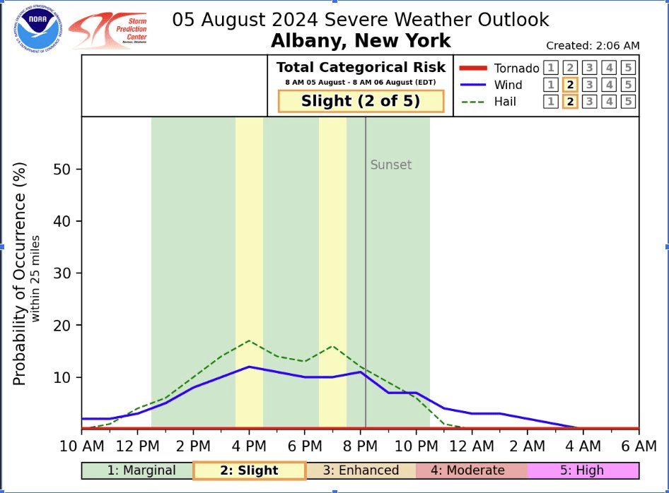
Heavy rain, lightning, damaging winds and the potential for hail are all part of the storm system moving toward the Capital Region.
A disturbance and cold front will bring another round of showers and thunderstorms this afternoon through tonight with a few severe thunderstorms also possible. Damaging wind gusts and large hail will be the primary threats. #nywx #vtwx #mawx #ctwx pic.twitter.com/2Ify80Kluc
— NWS Albany (@NWSAlbany) August 5, 2024
The severe weather expected Monday is not the result of tropical storm Debby, though the Capital Region may experience the remnants of that storm toward the end of the week.
 Local Shop Celebrates all things New York
 Malta Drive-In Wraps Up Its Season With Christmas Classics
 Could Parts of the Capital Region See Their First Snowflakes This Weekend?
 Proctors Turns 100 With Sara Bareilles, a New Marquee, and a Big Broadway Season
 Matchbox Twenty to Celebrate 30 years at SPAC